


Simple Satellite Weather Loops
Simple Satellite Weather Loops ਦਾ ਵੇਰਵਾ
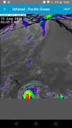
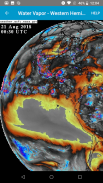
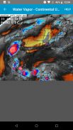
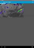
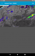
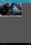
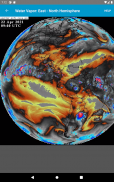
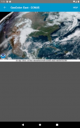
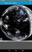
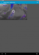
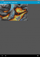
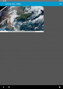
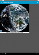
ਨਾਸਾ ਜਿਓਸਟੇਸ਼ਨਰੀ ਆਪ੍ਰੇਸ਼ਨਲ ਇਨਵਾਇਰਮੈਂਟਲ ਵਾਤਾਵਰਣ (ਜੀਓਈਐਸ) ਸੈਟੇਲਾਈਟ ਤੋਂ ਤਾਜ਼ਾ ਇਨਫਰਾਰੈੱਡ, ਦਿਖਾਈ ਦੇਣ ਯੋਗ ਅਤੇ ਪਾਣੀ ਦੇ ਭਾਫ ਦੇ ਲੂਪਾਂ ਨੂੰ ਵੇਖੋ.
ਇਹ ਐਪ ਮੋਰਚਿਆਂ, ਤੂਫਾਨਾਂ ਅਤੇ ਤੂਫਾਨਾਂ ਨੂੰ ਦੇਖਣ ਤੋਂ ਪਹਿਲਾਂ ਉਨ੍ਹਾਂ ਦੇ ਆਉਣ ਤੋਂ ਪਹਿਲਾਂ ਵਧੀਆ ਹੈ.
ਨਵੇਂ ਡੇਟਾ ਫਰੇਮ ਆਮ ਤੌਰ ਤੇ ਹਰ 10 ਤੋਂ 15 ਮਿੰਟ ਵਿੱਚ ਇੱਕ ਵਾਰ ਆਉਂਦੇ ਹਨ ਅਤੇ ਆਪਣੇ ਆਪ ਲੂਪ ਦੇ ਅੰਤ ਵਿੱਚ ਸ਼ਾਮਲ ਹੋ ਜਾਂਦੇ ਹਨ. ਚਿੱਤਰ ਟਾਈਮਸਟੈਂਪਸ UTC ਵਿੱਚ ਪ੍ਰਦਰਸ਼ਤ ਕੀਤੇ ਜਾਂਦੇ ਹਨ.
ਇਹ ਐਪ ਨਾਸਾ ਜਾਂ ਕਿਸੇ ਸਰਕਾਰੀ ਏਜੰਸੀ ਨਾਲ ਸਬੰਧਤ ਨਹੀਂ ਹੈ.
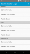
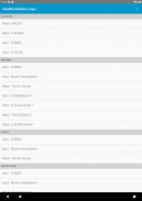
ਉਪਲਬਧ ਭੂਗੋਲਿਕ ਦ੍ਰਿਸ਼:
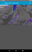
ਭੂ-ਰੰਗ:
ਪੱਛਮ - ਪੈਕਸ
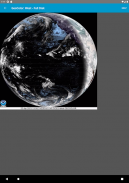
ਵੈਸਟ - ਪੂਰੀ ਡਿਸਕ
ਪੂਰਬ - ਕੋਨਸ
ਪੂਰਬ - ਪੂਰੀ ਡਿਸਕ
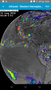
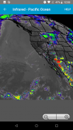
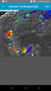
ਇਨਫਰਾਰੈੱਡ:
ਪੂਰਬ- ਕੋਨਸ
ਪੂਰਬ - ਉੱਤਰ ਗੋਲਾ
ਪੱਛਮ - ਪ੍ਰਸ਼ਾਂਤ ਮਹਾਂਸਾਗਰ
ਪੂਰਬ - ਕਨਸ ਬੈਂਡ 7
ਪੂਰਬ - ਪੂਰਾ ਡਿਸਕ ਬੈਂਡ 7
ਵੈਸਟ - ਪੈਕਸ ਬੈਂਡ 7
ਵੈਸਟ - ਪੂਰਾ ਡਿਸਕ ਬੈਂਡ 7
ਵੇਖਣਯੋਗ:
ਪੂਰਬ- ਕੋਨਸ
ਪੂਰਬ - ਉੱਤਰ ਗੋਲਾ
ਪੱਛਮ - ਪ੍ਰਸ਼ਾਂਤ ਮਹਾਂਸਾਗਰ
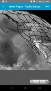
ਪਾਣੀ ਦੀ ਭਾਫ਼:
ਪੂਰਬ- ਕੋਨਸ
ਪੂਰਬ - ਉੱਤਰ ਗੋਲਾ
ਪੱਛਮ - ਪ੍ਰਸ਼ਾਂਤ ਮਹਾਂਸਾਗਰ
Simple Satellite Weather Loops - ਵਰਜਨ 1.5.2
(27-07-2024)Simple Satellite Weather Loops - ਏਪੀਕੇ ਜਾਣਕਾਰੀ
ਏਪੀਕੇ ਵਰਜਨ: 1.5.2ਪੈਕੇਜ: david.gross.satellite.weather.radarSimple Satellite Weather Loops ਦਾ ਨਵਾਂ ਵਰਜਨ
ਹੋਰ ਵਰਜਨ


ਇੱਕੋ ਸ਼੍ਰੇਣੀ ਵਾਲਿਆਂ ਐਪਾਂ

ਤੁਹਾਨੂੰ ਇਹ ਵੀ ਪਸੰਦ ਹੋ ਸਕਦਾ ਹੈ...


